Downloads: GPX File | KML File | Google Maps File | OS Online route
About Dollywagon Pike | About Nethermost Pike | About Helvellyn
Parking Location | OS Map | Current Weather
We previously attempted Helvellyn from the popular route (from Glenridding). Unfortunately, we had to turn back due to some pretty poor weather, vastly increasing wind and minimal visibility. This time we wanted to avoid striding edge and swirral edge and focus on hitting the three peaks of Dollywagon Pike, Nethermost Pike and Helvellyn.
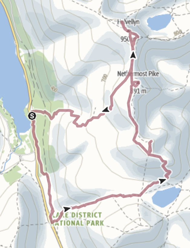
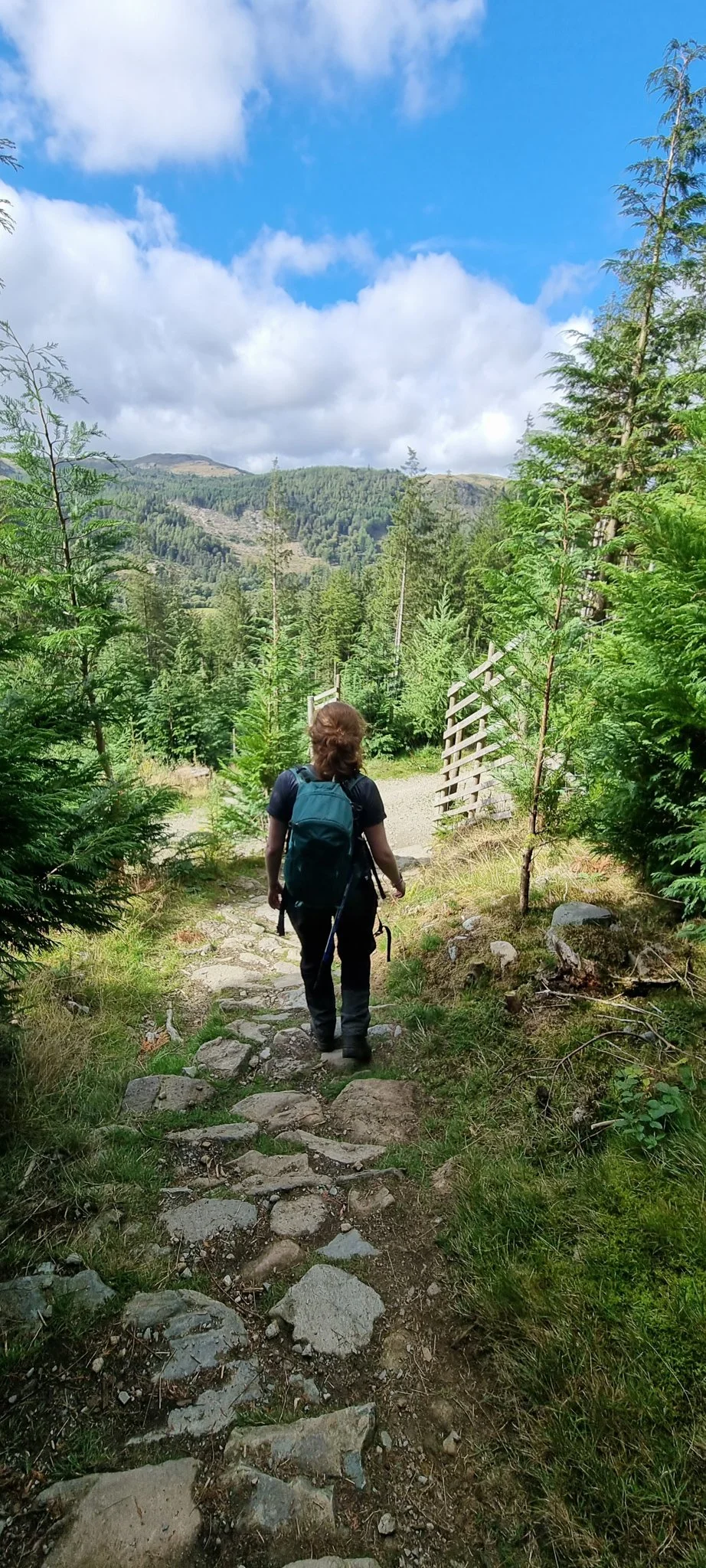
Starting from Wythburn Church car park we headed along the woodland track parallel with the main road, it seems like a much less used path than we expected but it’s very clear to follow. We soon got onto the track of Red Brow which then leads up to a small bridge over a waterfall, down from Birkside Gill Copper mine. We continued to follow the path from here, which was still very clear but uneven. As the woodland drops away, the grassy verge begins to take shape. At this point, you’re a bit higher than the road so the view down the valley starts to open up. We soon dropped down towards a wall and followed this until it curved around and ran over Raise Beck. The map showed a way by the wall over the small river, but as we couldn’t see one, we made our way over to a section of the river where other walkers had clearly made a crossing. We followed their steps down the loose slate before making our way over the river and up the other side.
Once over the river, it was easy to get back onto the path and head once again parallel to the main road at Dunmail Raise. Further along, we crossed raise beck again (due to it forking further up the hill) and it’s here that we turned left and headed up to the fells.
The easy-to-follow route is a mix of dirt paths and rocky steps. The path stays on the right side of Raise Beck and carries on up to the higher fells. You follow the steam past its many waterfalls and there are some big steps. There are a few places along the way where you need your hands for support. It's a great way up the hill and due to the stepped nature of the path, you make pretty good progress. Eventually, further along, the path starts to flatten out and move away from the river. It’s at this point that we gained our first spectacular view. Just over the brow of the hill, you see Grisedale tarn open out most beautifully. It stretches out far across the valley and is set between the three peaks of Fairfield, Seat Sandal and Dollywagon Pike. It’s a stunning area, and we saw a couple of people who were just packing up from a wild camp here. Understandable as it’s just so beautiful and it's one of those areas that you feel is totally in the middle of nowhere. Great for a bit of solitude.
There are two paths along from here, we chose the higher path as it joined the next path higher up, but both will get you there. As we made our way along here the views of Grisedale Tarn kept changing and giving you new, impressive ways to see the tarn. Once at the bottom of Dollywagon pike, you can see the steep route up to the fell, luckily this path is a switchback ensuring that it’s not too difficult. Again, it’s rocky steps and we took our time making our way up. The view behind the path over Grisedale tarn, towards Fairfield is wonderful. We did spend more time looking at the grassy sides than the rocky path in front. As this forms part of the coast-to-coast walk, the path is well maintained and eventually, after some harder metres, we reached the end of the switchback. Here the path flattened out a little. The path swings you around the base of Dollywagon Pike and the views up the valley now start to show, the far distance fells stretch out for as far as you can see. Soon, we got to a crossroad.
Turning right here takes you directly to Dollywagon Pikes peak and that’s exactly where we headed. The path here is less obvious, following a way through to the grassy peak, you hit the summit and the views are some of the best. You see down the valley of Grisedale and can take in the peaks of Fairfield, St Sunday Crag and more.

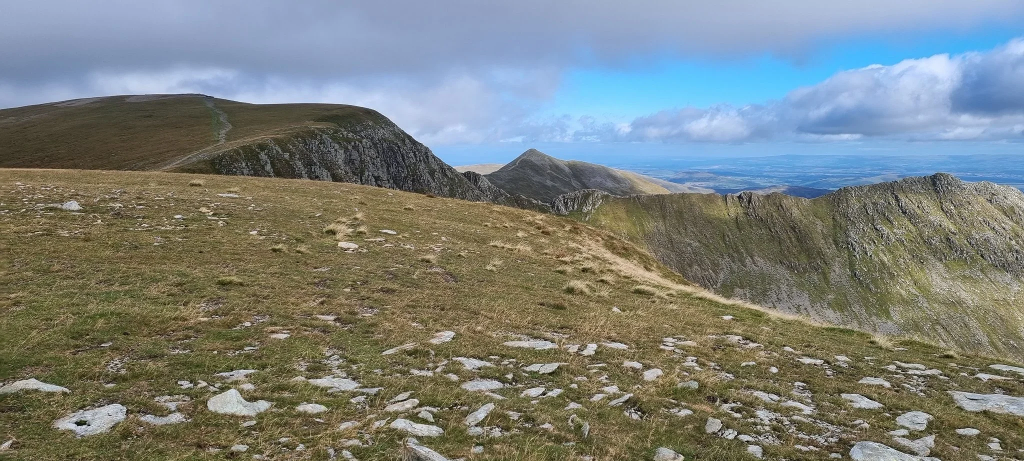
We exited Dollywaggon the way we went up, while on the peak, you can see another route off and toward the next fell. This other route is tempting, however, we had been advised to avoid this and it wasn’t long until we were back on the coast to coast path and heading for our second peak. The path here is great, with amazing views out to the mountains all around. Nothing difficult and you can get a bit of a pace on. It was a wind trap, so take care to pack the right clothing. The high path was everything we love from mountain walking! It ebbs and flows both up and down, as well as side to side along the ridge as well as just down from the ridge and we quickly covered the distance. The peak to the right starts opening out and flattening as you get nearer to Nethermost Pike. Once near the peak, you can make your way through what feels like a miniature boulder field to get to the cairn. It’s easy to find, but you must watch your step over the very rocky ground. We found a small storm shelter here and decided to have our lunch out of the wind.
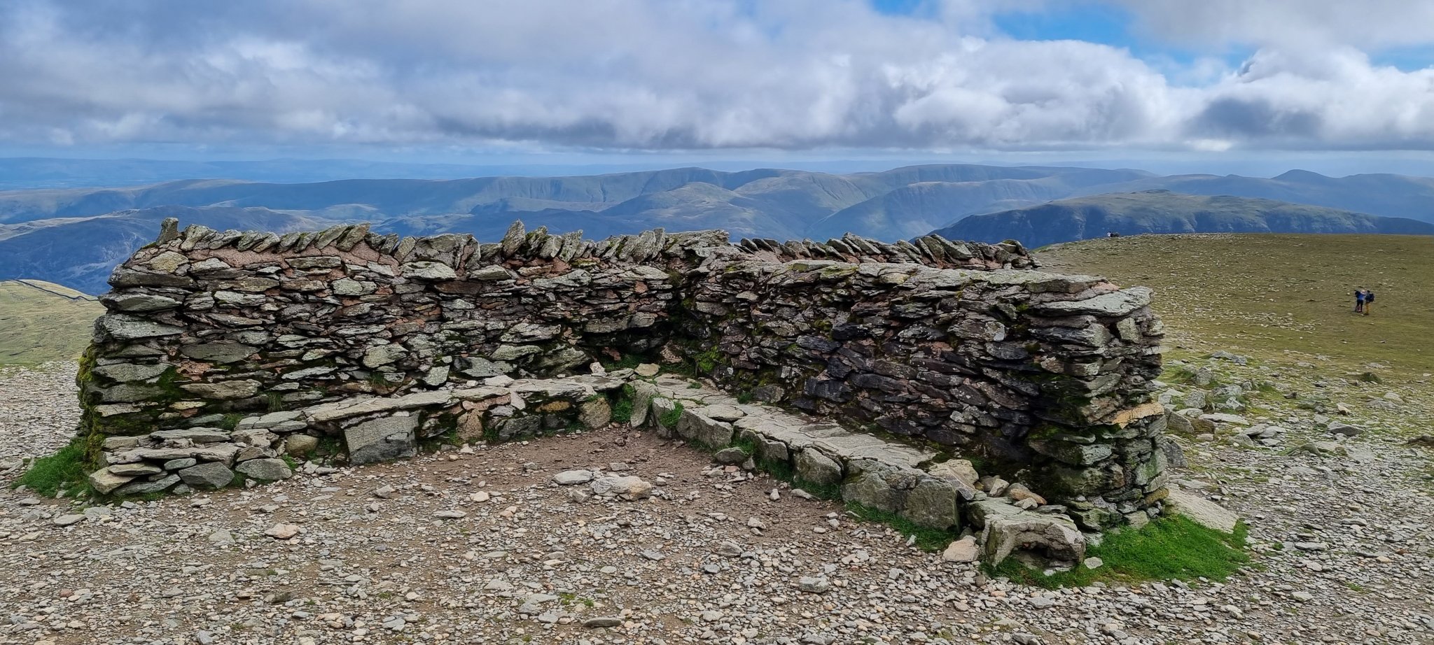
Returning to the main path is once again very easy and we soon had the dominant Helvellyn in our sights. We followed the wide path down from Nethermost Pike and passed the route that we planned to take off the mountain after doing Helvellyn. It went down to the left. Taking note of where this was, we carried on and started the short climb to the peak. Towards the top, you can easily spot the huge storm shelter and before you reach it, you pass by the Avro 585 Gosport Plane Landing Plaque which marks the spot where a plane landed on the mountainside! Reading this stopped us in our tracks and made us take a little more time, which was perfect to take in the wonderful views right before we hit the peak of Helvellyn. The summit view was recently voted as the best in the UK and for good reason.
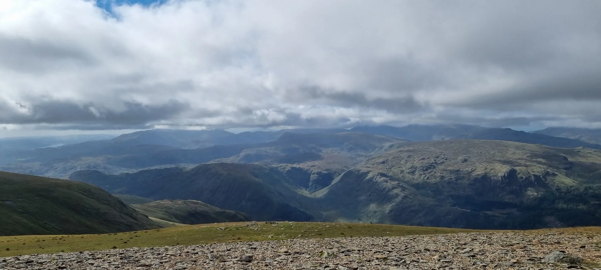
Due to the height, not only can you see for miles in every direction, and therefore all the peaks in every direction become visible, as well as parts of Thirlmere and the very impressive Red Tarn. The bowl it sits in between Helvellyn, Catsycam and High Spying How allows for this beautiful tarn to sit proud and dominant in your view. We spent some time taking in a few of the wonderful wide paths and getting as much of the view as we could before heading down to the path where Striding Edge joins the peak. We watched a few people making their way across and then headed back onto the main path which we used to reach the peak.
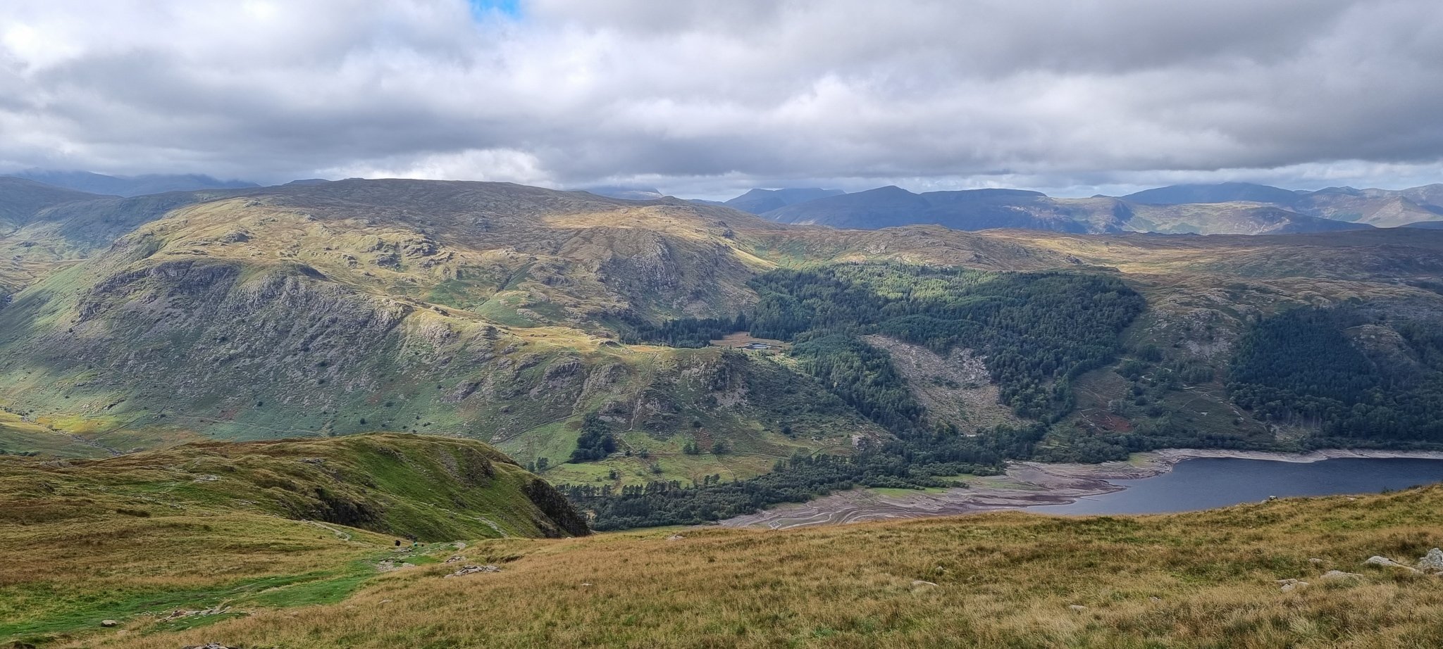
We followed the path over old ground a little way and found our exit path, now on the right after coming at it from a different direction. This way takes you back towards the Thirlmere Valley. The route is straightforward and for a while doesn’t descend much at all. Once the view to Thirlmere starts to show you can also make out the switchbacks of the path, these run down for a good way before you hit the rocky Comb Crags. Here the path seems to go off into the crags, but just gracefully passes through a narrow opening before again pushing you into a few zig-zag twists. As you move off the fells, the view of Thirlmere opens even more and presents you with one last amazing view to add to the abundance we had on this walk.
Into the woodland at the bottom and the path and it gets a bit steeper again, so taking our time (and starting to ache a little!) we slowly made our way down. Soon, we followed the path out and back onto Wythburn Church car park where we started.
This was one of my favourite routes we have done over the fells. The views are endlessly beautiful and spectacular while the walk never becomes too difficult. It’s a lot of metres covered, and a lot of height too, but all the paths are good and there was nothing like a Striding Edge to worry about. One other benefit of this route was that it is a much quieter way to the top than from the more popular side, meaning fewer people (until the Helvellyn peak) and more chance of a parking space. If you’re after a day out in the mountains to remember, this is a route that will give you just that.